Solving the Nautical Triangle, i.e. Sight Reduction
The solution can be found either with a calculator or with specially prepared tables. Before calculators existed, people were used to precompute complex calculations, and these results were published in various table books. In celestial navigation, table books are still used because of their reliability. The book works even if the calculator runs out of batteries.
For example, the NP 401 Sight Reduction Tables for Marine Navigation help solve the nautical triangle. From the tables you can read the star’s altitude above the horizon and its azimuth. As input data you need an
Typically, it is sufficient to know an estimated current longitude. The assumed position is obtained from your dead reckoning calculations while sailing. In position fixing, the assumed position may differ from the real position by up to 60 nautical miles and still produce sufficiently accurate results. If you use the tables in reverse—i.e. to identify a star (covered later)—the accuracy is still sufficient to distinguish navigation stars, planets, the Moon, and the Sun from each other. The Sun is, of course, easier to identify by simpler means.
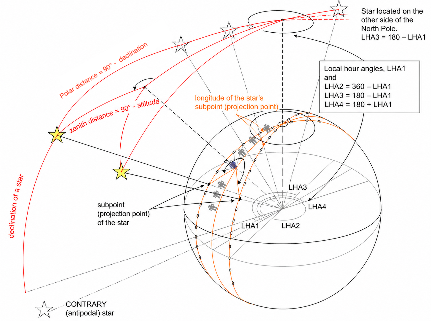
The pages of the Sight Reduction Tables book are organized by local hour angle (LHA). Each page contains results computed for four different hour angles, labeled LHA1, LHA2, LHA3, and LHA4. As can be seen, when LHA1 is less than 90° and LHA2 = 360° − LHA1, the resulting nautical triangles are mirror images of each other. Their angles and side lengths are identical. To save space, the values are not duplicated. One only needs to know whether the azimuth is east or west.
In the NP 401 Sight Reduction Tables for Marine Navigation, the left page and the lower part of the right page form the so-called SAME area. When the star’s declination is northern—meaning its projection point lies north of the equator—and you are in the Northern Hemisphere, the solution is taken from the SAME area.
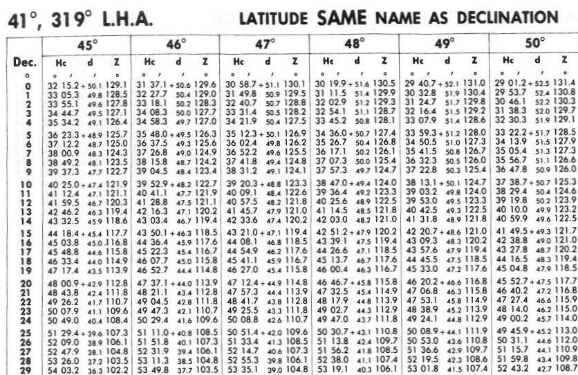
The image shows part of the left page of the Sight Reduction Tables. It lists the altitude of the star’s projection point (Hc) and the azimuth (Z) for stars whose local hour angle (LHA) is 41° or 319° = 360° − 41°. As seen earlier, these are identical triangles, except that they are mirror images of each other. If you flip the Sight Reduction Tables page, the next page would list solutions for LHA 42°.
The columns 45°, 46°, 47°, etc. represent latitudes and give the corresponding values depending on your position. A single book cannot contain all latitudes. For use in the Baltic Sea, the Sight Reduction Tables for Marine Navigation Latitudes 45°–60° is suitable. The same book can be used for all latitudes between 45°–60° North or South. The same solutions also work in the Southern Hemisphere if you replace the North celestial pole with the South celestial pole and interpret azimuth as measured from south toward east or west. When calculating true direction, you only need to remember whether you are north or south of the equator. See section True Direction to a Star.
The upper right part of the page is the CONTRARY area.
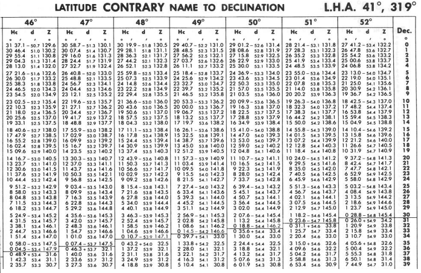
In this area, the star’s projection point is in the opposite hemisphere from you. On the right-hand page margin, declinations are shown starting from zero upward. These therefore represent southern declinations if you are in the Northern Hemisphere. For example, if you are at latitude 45°N, a star directly south of you has local hour angle 0°, and a star declination of 45°S will at best reach the horizon. It lies on your horizon. As Earth rotates and the star’s local hour angle increases, it immediately sinks below the horizon.
Below is the full right-hand page of the Sight Reduction Tables for LHA = 41°. If you turn the page, the next spread would show solutions for LHA = 42°.
From this you can see that if you are at latitude 45°, you can observe a star whose true bearing (azimuth) is 148.4°, or 360° − 148.4° = 211.6°, and whose projection point lies on southern latitude S 37°. You will see it just above the horizon. The Sight Reduction Tables show that its altitude is 2.2° above the horizon.
A star in the same direction whose projection point lies further south will be below your horizon. Between these values there is a dividing line in the 45° column. Conversely, a star with declination on northern latitude N 38° is visible to your north. Its local hour angle (LHA) is 180° − 41° = 139° or 180° + 41° = 221°, as shown in the lower right corner of the page. In the first image of this section, these correspond to stars with LHA3 or LHA4. They would be seen either in true direction 31.1° or 360° − 31.1° = 328.9°.
If you move one degree further north, to latitude 46°, you can no longer see the star whose projection point is at southern latitude S 37°. It has dropped below the horizon as you moved north. Instead, a star becomes visible from the north whose local hour angle (LHA) is 139° or 221°, and whose projection point lies at northern latitude N 37°.
If you were not completely confused by this, you may have noticed that the table pages only contain solutions for nautical triangles where the local hour angle (LHA) is in whole degrees. This is intentional. Other values are not needed for reasons that will become clear later. However, we do need solutions for cases where the celestial body’s declination (dec) is not in whole degrees. In those cases, interpolation is used. The book contains an interpolation table that allows you to compute the star’s altitude even when its declination is not an integer number of degrees.
Interpolation means deriving a value that lies between two tabulated values by using the values before and after it.
C o n t e n t s
- Position fixing from stars
- Night sky
- Celestial sphere
- What you see from the North Pole as Earth rotates
- How the night sky changes when traveling to the equator
- Effect of Earth’s rotation on the sky at the equator
- Celestial meridian, upper and lower culmination
- Change of star altitude at the poles, equator, and between
- Declination
- Example of determining latitude
- Hour angle, Greenwich Hour Angle (GHA)
- Aries, celestial Greenwich reference
- Sidereal hour angle (SHA)
- Local hour angle (LHA)
- Relation between hour angle and time
- Example of longitude and latitude from the Sun at noon
- Relation between angles, degrees, and nautical miles on Earth
- Position circle
- Azimuth
- True bearing to a star
- Nautical triangle
- Solving the nautical triangle (sight reduction)
- Position fixing using Marcq Saint Hilaire’s intercept method
- Star identification
- Details and practice
- Time
- Time difference (ΔT)
- Altitude measurement
- Example of position fixing
- Twilight
- Calculation of twilight time
- Navigation exam
Hamburg VII 2026