Example of determining latitude
You are sailing somewhere in the North Atlantic. It is evening twilight, so you can see both the horizon and stars through a telescope. You observe, among others, Alnilam rising toward its upper culmination point. This is the point where Alnilam is at its highest altitude above the horizon. Using a sextant, you can measure the angle between yourself, Alnilam, and the horizon. The angle increases, increases, increases, and then the next measurement shows it has slightly decreased. The largest angle you measured to Alnilam was 42° 13’ (42 degrees and 13 minutes). At that moment, Alnilam was at upper culmination and directly south of you. Now we need to determine your latitude.
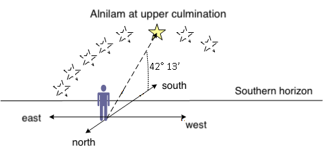
We know that the declination of Alnilam is 1° 12’ S, so the situation is as follows:
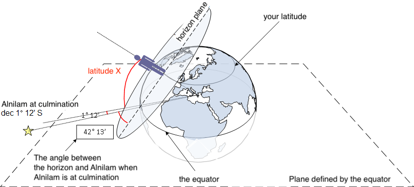
Your latitude is equal to the angle between the plane of the equator, the Earth’s center, and your position.
The angle between the horizon you observe and your latitude is 90°.
Therefore, the angle you measure to Alnilam is 42° 13’ + Alnilam’s declination 1° 12’ S + latitude X = 90°.
In other words…
X = 90° - 42° 13’ - 1° 12’ = 46° 35’.
You are at latitude 46° 35’.
A simpler illustration of the situation:
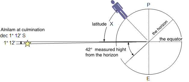
|
Alnilam measured altitude above the horizon |
Alnilam’s declination, i.e. how far it is above the plane of the celestial equator |
your latitude |
||||||
| 42° 13’ | + | 1° 12’ | + | X | = | 90° |
C o n t e n t s
- Determining position from stars
- Night sky
- Celestial sphere
- What you see at the North Pole when Earth rotates
- How the night sky changes when traveling to the equator
- Effect of Earth’s rotation on the sky at the equator
- Celestial meridian, upper and lower culmination
- Change in star altitude at the North Pole, equator, and between them
- Declination
- Example of determining latitude
- Hour angle, Greenwich Hour Angle (GHA)
- Aries, celestial Greenwich
- Sidereal Hour Angle (SHA)
- Local Hour Angle (LHA)
- Relation between hour angle and time
- Example of determining longitude and latitude from the Sun at noon
- Relation between angles, degrees, and nautical miles on Earth
- Celestial navigation circle
- Azimuth
- True bearing to a star
- Nautical triangle
- Solving the nautical triangle (altitude calculation)
- Position fixing using Marcq Saint-Hilaire intercept method
- Star identification
- Details and practice
- Time
- Time difference (ΔT)
- Altitude measurement
- Example of position fixing
- Twilight
- Calculating twilight time
- Navigation exam
Hamburg VII 2026