Celestial Navigation
Copyright (c) Jukka Talvio 2010 - 2026
Until fairly recently, all ships sailing on the open seas determined their position using stars, the sun, and planets. A compass and log, the ship’s speedometer, are not sufficient when the distance to coastal landmarks becomes large enough.
The principle of celestial navigation is simple. In textbooks it is often presented in great detail and with so many new terms that it becomes difficult to understand what is actually happening. In this text, determining position using stars is explained in a more understandable way.
Position Fixing
The navigator climbs onto the deck at dusk. The sun is just setting, and the first stars are already visible to the naked eye. An experienced navigator holds a sextant equipped with a clock. Using the sextant, he measures the altitude of two stars that he selected in advance above the horizon. At the exact moment he measures the altitude, the navigator presses a button on the sextant’s clock. It records the precise time of the observation. The sextant clock reading must still be compared with the ship’s actual chronometer, which is more accurate than the sextant clock.
Sitting at the table, the navigator takes into account the difference between the sextant clock and the chronometer, the sextant error, the height of the observation point above sea level on deck, atmospheric refraction of light, and calculates the true altitude of the stars above the horizon.
For the following steps, the navigator needs an estimated current position of the boat with an accuracy of about 60 nautical miles. Even if the estimate is more inaccurate than that, the resulting error would still not be very large.
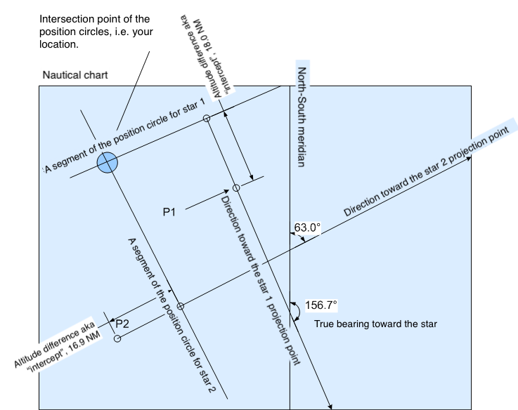
Using two reference books, the Nautical Almanac and the Sight Reduction Tables, the navigator calculates the points on Earth directly beneath the observed stars at the moment of measurement. These are their geographical positions, or projection points. He calculates the direction from the estimated current position to the projection points of the stars and draws a line on the chart from the estimated position toward the projection point of the first star. From the measured altitude of the star, he calculates the boat’s distance from the projection point at that moment and draws a perpendicular cross-line on the direction line at the appropriate point. This is called the line of position. The boat’s true position lies somewhere on this line. He then draws another line from the estimated position toward the projection point of the second star and constructs a second line of position. The intersection of these two lines gives the boat’s position determined from the stars.
If the previous explanation sounded like gibberish and you would like to understand in more detail what happened in the story, the rest of the text is intended for you.
C o n t e n t s
- Celestial Navigation
- The Starry Sky
- The Celestial Sphere
- What You See from the North Pole as the Earth Rotates
- How the Starry Sky Changes When You Travel to the Equator
- The Effect of Earth’s Rotation on the Starry Sky at the Equator
- The Celestial Meridian, Upper Culmination, and Lower Culmination
- Changes in Star Altitude at the North Pole, the Equator, and Between Them
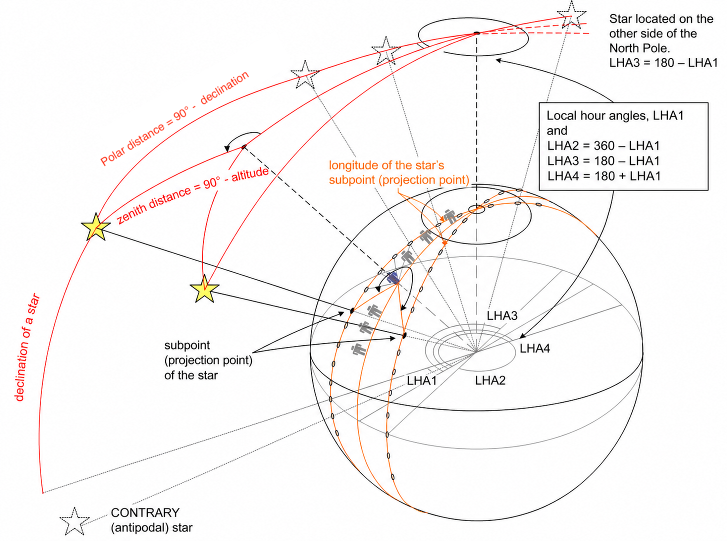
- Declination
- Example of Determining Latitude
- Hour Angle, Greenwich Hour Angle (GHA)
- Aries, the Greenwich of the Celestial Sphere
- Sidereal Hour Angle (SHA)
- Local Hour Angle (LHA)
- The Relationship Between Hour Angle and Time
- Example of Determining Longitude and Latitude from the Sun at Noon
- The Relationship Between Angles, Degrees, and Nautical Miles on Earth’s Surface
- Circle of Equal Altitude
- Azimuth (A, Azimuth)
- True Bearing to a Star
- The Navigational Triangle
- Solving the Navigational Triangle, or Sight Reduction
- Celestial Navigation Using Marcq Saint Hilaire’s Intercept Method
- Star Identification
- Details and Practice
- Time
- Time Difference (ΔT)
- Altitude Measurement
- Example of Position Fixing
- Twilight
- Calculating Twilight Time
- Navigation Association Examination
Hamburg VII 2026